
The Last Mile: The Gap Between Microtransit Service and Communication
At a recent community meeting, an older woman living in Belle Haven, a residential neighborhood cut off from the rest of Menlo Park by Highway 101, wanted to know how to get to her home from her healthcare appointments at the Kaiser Redwood City Medical Center. The transit services she needs to make this trip already exist: a SamTrans bus can take her from Redwood City to Belle Haven and a SamTrans Ride Plus microtransit van can connect her to her home in Belle Haven. But as far as the region’s trip planning tools are concerned, they aren’t part of the same network.
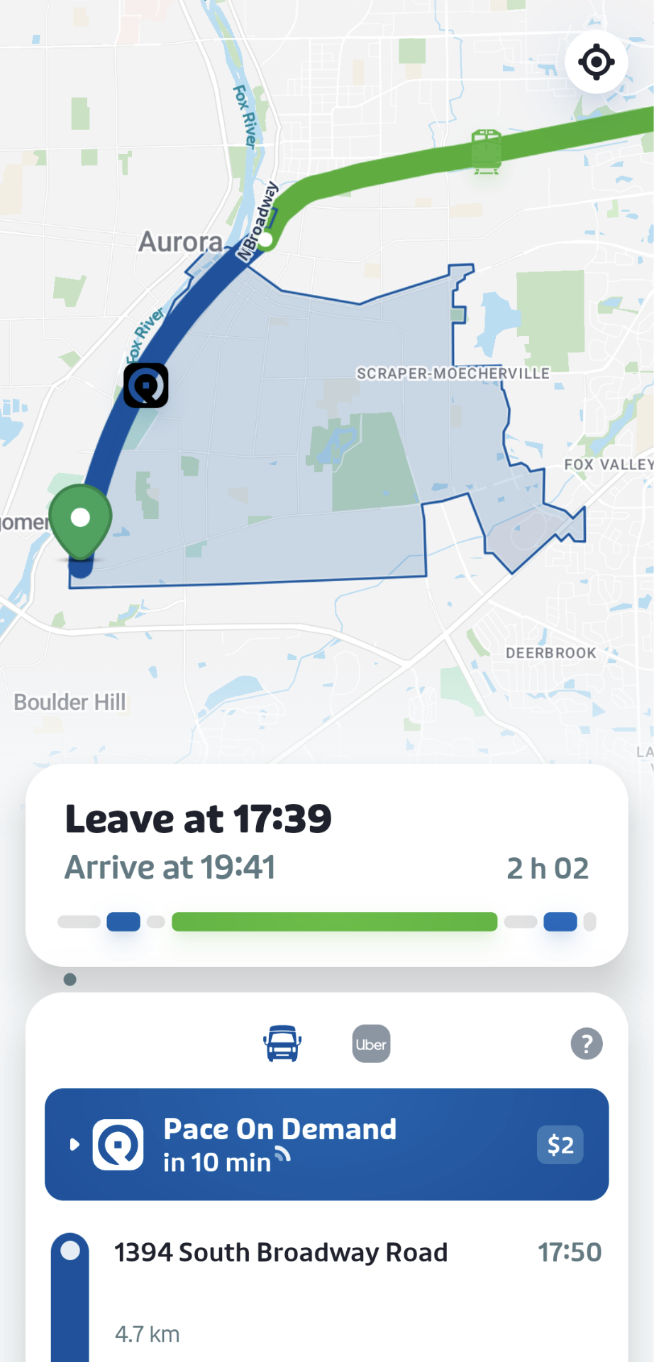
In Chicago, apps can tell riders to take the train to Aurora and finish their journey with Pace On Demand microtransit.
This is the norm for planning trips involving both fixed route and microtransit services across the Bay Area. Cities around the country show that this doesn’t have to be the case: using open data standards, apps can now help riders get around using a combination of services.
It’s time for the Bay Area to get on board – for agencies to publish open data for their services, and for the Metropolitan Transportation Commission to include them as part of the region’s transit network.
The Rider Communications Problem
Microtransit services have grown increasingly common in the Bay Area. Today, there are some 14 different services operating in all nine Bay Area counties covering approximately 1 million residents.
However, riders have a hard time taking microtransit for trips that go behind the limited area served by the specific microtransit service. To take a trip on fixed route transit, a rider opens an app and enters their destination. The app tells them which routes to take, and when. If the route uses two buses, or a bus and a train, the app shows them when and where to make the connection.
A recent SamTrans survey showed that three quarters of riders use Google Maps or another trip planning app when riding. In addition, over half of SamTrans Ride Plus riders connect to a fixed-route service. Despite this, none of the trip planning apps available to riders for SamTrans’ fixed-route service allow a rider to plan a connecting trip, or discover microtransit options.
To take a trip on a microtransit service, riders need to find and download a different, special app for that service. If they are connecting to a fixed route bus or train, they need to separately look up when that trip leaves the stop or station and then order their microtransit trip to get them there in time.
We’re using SamTrans as an example because RidePlus is one of the higher profile microtransit services in the region. The same issues apply all the more so for other, less well-publicized microtransit services.
With many of the services run by cities instead of by existing transit agencies, riders may not encounter them on agency maps or places they already look for transit information. They must learn the service exists, look up information about it on the agency’s website to learn the precise area it serves and hours it operates, and then download the service’s app before they can understand if it works for them.
Standards are Here
GTFS is an open data standard that allows transit agencies to publish information about their services in a consistent, standardized format. This data is then used by apps like Google Maps, Apple Maps, and Transit to help riders plan trips. Most transit agencies are now required to publish GTFS data for their fixed-route services. As a result of GTFS's near-universal adoption, riders now expect and trust these apps to show them the correct information at the correct time.
Until recently, there wasn’t a widely adopted way for trip planning apps to help riders understand how to get around with microtransit services.
GTFS now includes “flex” features that can be used to help riders with all sorts of flexible transit services that exist in the Bay Area, from app-based microtransit and demand-response services to flex zones and flag stop services. A complementary standard, GOFS, can provide dynamic information such as availability and wait times.
GTFS “flex” features can now be used by journey planning apps like Transit to help riders make multimodal journeys. An ecosystem is emerging around the standards, and the software vendors behind most of the region’s microtransit services – RideCo, The Routing Company, Spare Labs, and Via – now support GTFS Flex, GOFS, or both. Around the country, agencies in Chicagoland, Miami Beach, and across Minnesota have already deployed the technology.
The GTFS “flex features” were developed with the help of staff at the California Integrated Travel project of Caltrains. California agencies looking to publish feeds independently of their microtransit vendors can get additional help from Caltrans staff to assist with GTFS Flex.
Microtransit Services Need It Now
Microtransit services face competing pressures. They need enough riders to make service cost-effective, but they also need riders with reasonable fixed-route options to take those instead to leave scarce capacity available for riders with no other choices.
Putting microtransit into trip planning apps allows exactly that: riders with fixed-route options will be shown those options, while riders previously told they had no options will be shown the microtransit services in their area.
A Regional Responsibility
As microtransit services mature, it’s important that they become an integrated part of not just trip planning, but regional transit policy and analysis. The region’s Network Management initiative, run by the Metropolitan Transportation Commission in partnership with transit agencies, is expanding the regional wayfinding project to more parts of the Bay Area, and over the next year, new local area maps will be deployed in places like Suisun City and Palo Alto at transit centers served by microtransit. As part of expanding wayfinding into these areas, it’s important that the new Neighborhood Maps and Local Transit Maps include microtransit in a well thought through manner.
This also fits into the broader ongoing work on the region’s Transit Transformation Action Plan to help treat the region’s transit as a single connected network. The Network Management initiative should establish an expectation that agencies publish microtransit data in an open format. MTC should also include microtransit services in the analyses being done to allow planners at MTC, transit agencies, and cities considering microtransit to better understand the role the services play in the region, and how to steward more useful, sustainable service. Let riders see microtransit as part of the same network they already use.